
EagleNXT
EagleNXT eBee TAC
SKU#: BN966
Ships via Standard Ground
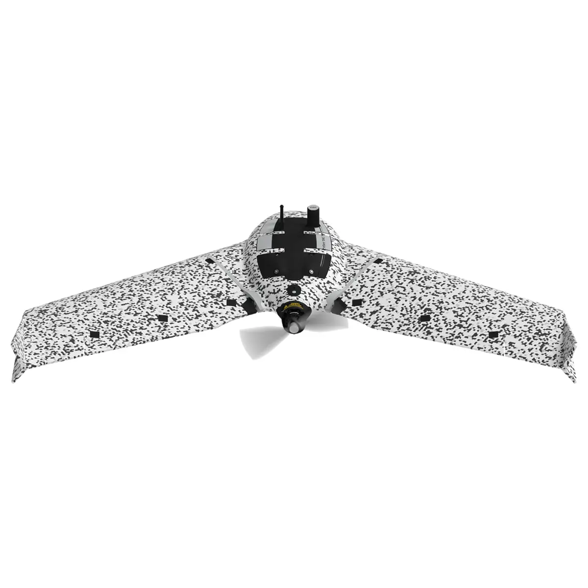
The eBee TAC Tactical Mapping Drone is a Blue UAS-certified, NDAA-compliant fixed-wing drone engineered for defense, public safety, and disaster response missions. With up to 90 minutes of flight time, RTK/PPK-enabled precision mapping, and AES-256 encrypted data security, it delivers unmatched performance in disconnected environments. Designed for tactical reconnaissance, border surveillance, and infrastructure assessment, the eBee TAC integrates seamlessly with ATAK and Google Earth Enterprise, making it the ideal cyber-secure UAV for mission-critical operations. Lightweight, portable, and operable by a single user, it’s the go-to solution for agencies seeking a long-range drone with situational awareness capabilities.
Looking for a quote? Simply add your items to the cart and choose Request for Quote during checkout.
Enter a value between 1 and 100000000 in increments of 1.
Earn Darley Dollars with this purchase
The eBee TAC is a fixed-wing tactical mapping drone engineered for defense, public safety, and governmental operations in disconnected, contested, or GPS-denied environments. As a Blue UAS-certified and NDAA-compliant platform, it meets the highest standards for secure procurement and mission-critical deployment by the U.S. Department of Defense and allied agencies.
Designed for single-operator use, the eBee TAC is lightweight, portable, and deployable in under three minutes. It delivers up to 90 minutes of flight time, high-resolution mapping, and real-time situational awareness through encrypted data workflows and seamless integration with platforms like ATAK and Google Earth Enterprise Platform (GEEP).
Features
- Blue UAS Certified & NDAA Compliant: Fully approved for direct U.S. DoD procurement
- Cybersecurity: AES-256 encrypted radio link and SD card; log file suppression for operational security
- Flight Time: Up to 90 minutes per mission
- Coverage: Maps up to 1,235 acres (500 ha) at 400 ft altitude in a single flight
- Accuracy: Achieves 1.5 cm (0.6 in) absolute accuracy with RTK/PPK—no ground control points required
- Deployment: Operable by one person; deployable in under 3 minutes
- Silent Mission Mode: Acoustically undetectable at 300 m (984 ft) for covert operations
- Durability: Curv® thermoplastic composite underbody; IP67-rated transport case for rugged environments
- Software: eMotion flight management with offline planning, multi-drone operations, and live flight adjustments
- Camera Payloads: Swappable RGB, patented 3D, and thermal sensors
- Situational Awareness Integration: Compatible with ATAK and GEEP for tactical edge mapping
Key Benefits
- Rapid deployment in under 3 minutes
- RTK/PPK-enabled mapping with 1.5 cm precision
- Maps up to 1,235 acres in a single 90-minute flight
- Low acoustic and visual signature for stealth missions
- AES-256 encryption and log suppression for secure data handling
How It’s Used
- Defense & Military: Tactical reconnaissance, terrain mapping, and mission planning
- Disaster Relief: Rapid mapping of affected zones for rescue coordination and resource deployment
- Border Surveillance: Long-range monitoring with minimal acoustic footprint
- Public Safety: Real-time situational awareness in disconnected or remote environments
- Infrastructure Assessment: High-resolution mapping for planning, inspection, and maintenance
Software & Data Workflow
- Flight Planning: eMotion software supports 3D simulation, offline maps, and multi-drone control
- Data Collection: Swappable sensors capture RGB, 3D, and thermal imagery
- Post-Processing: Compatible with PIX4D, Agisoft Metashape, DroneDeploy, Esri ArcGIS, Trimble, and more
- Data Security: Encrypted SD card ensures secure data handling in the field
- Situational Awareness: Integrates with ATAK and Google Earth Enterprise Platform (GEEP)
Certifications & Compliance
- Blue UAS Certified
- NDAA Compliant
- STANAG Transport Case
- AES-256 Encryption
Use Cases
- Military Reconnaissance
- Disaster Relief Mapping
- Border Surveillance
- Infrastructure Assessment
- Tactical Edge Operations (via ARTEMIS Kit)
Hardware and Build
- Material: Expanded Polypropylene (EPP) with Curv® thermoplastic composite underbody for durability
- Wingspan: 45.7 in (116 cm); detachable wings for easy transport
- Transport Case: IP67-rated, STANAG-certified military-grade case
In the Box
- eBee TAC Gov Aircraft
- Battery (x2)
- Charging Cables (x4)
- Sensor Protector (x9)
- Spare Prop (x2)
- USB Modem
- 32 GB microSD Card (x2)
- Charger, Micro USB Cable
- Battery Power Cable
- Foam Glue
- Pitot Pro Kit
- Manuals
- Hard Case
- Color: Pixel Camouflage
- Cruise Speed: 25–68 mph (40–110 km/h).
- Wind Resistance: Up to 28.6 mph (46 km/h).
- Landing: Linear landing with 5 m (16.4 ft) accuracy using Steep Landing technology.
- Radio Link Range: Nominal 3 km (up to 8 km).
- Ground Avoidance: LiDAR-based, up to 394 ft (120 m).
- Service Temperature: -15°C to 40°C (5°F to 104°F); requires sun protection above 35°C
- Weight: 3.5 lbs (1.6 kg)
- Wingspan: 45.7 in (116 cm)
- Flight Time: Up to 90 minutes
- Transport Case: IP67-rated, STANAG-certified military-grade case
- Flight Range: Up to 34 mi (55 km)
- Model: SF054000